The
Williams Lake area has
been subjected to the action of great ice sheets about 10,000 years ago
during Pleistocene times.
Today, glacial
deposits from these ice sheets can be found in the sides of the Williams
Lake River Valley. These deposits are exposed in some areas where the
valley wall has given way to gravitational forces or along stream cut
banks where water erosion exerts its influence. As ice retreated from
the area in a South Easterly direction, the Fraser River was dammed and
a lake formed that covered the entire Williams Lake area. This glacial
lake had water levels up to 2500 ft. (760 m) above present day average
sea level.
Near the
top of the valley sides there are deposits rich in shells that provide
evidence of the former glacial lake. Over the years since the glacial
epoch, Williams Lake River has eroded away significant amounts of glacial
sediments and redeposited them as fluvial sands and gravels.
The Williams
Lake area boasts a moderate climate with four distinct seasons that allow
for a variety of recreational activities. The average July temperature
is 22 C. while the average January temperature is -10 C. The annual precipitation
is 40 cm with snowfalls adequate for a host of winter recreational activities.
The Williams Lake area has about 120 frost free days per year and a growing
season of 113 days (May 22 to Sept 19). The Williams Lake River Valley
is deemed to have growing conditions that are more favourable than the
surrounding area making it of considerable ecological interest.
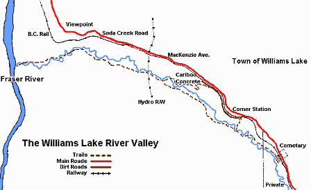
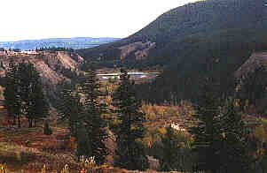
The river
valley starts within the boundaries of the City of Williams Lake as a
narrow green strip draining from the north end of Williams Lake and is
surrounded by industrial and commercial development. West of the city
boundary, the valley is at its widest. As it nears the Fraser River, the
Valley narrows again with high spectacular cliffs rising over 150 metres
with deep gullies on each side. A variety of trees, shrubs, flowers and
grasses are found in the valley.
The highest
diversity of plant communities and species are found where the valley
is at its widest; in other words closest to the residential and industrial
areas influencing the valley. Here large black cottonwoods are abundant
and represent one of the few, northerly areas near Williams Lake where
large specimens of this species remain.
Information & Services
If you would like to have your business listed, please Click Here.
Other areas
of the valley boast very attractive open parklike areas of Douglas
fir and white birch.
Within the river valley, large changes in plant community composition
occur over short distances due to the effects of slope, aspect, microclimate,
soil materials and drainage. For example, marked floral changes are evident
between the moist valley bottom and the sunbaked south slope of the north
valley side. These dry south slopes are frequently inhabited by sumac
and rabbit bush shrubs that are generally uncommon to the area. Both shrubs,
however, are more typical of the Dry Interior Zone south of the Cariboo.
The bird
life in the valley is extremely diverse because of the wide range
of habitats including running water, shorelines, marsh, low brush, tall
deciduous and coniferous trees, standing dead trees, clay banks and open
grasslands. Most of the 252 species of birds found in the Cariboo region
can be seen in the Williams Lake River Valley at one time or another.
In fact, several birds not thought to occur in the Cariboo region were
first sighted in the Williams Lake River Valley. These include the wood
duck and winter wren that have since been found in other areas within
the region. Interesting birds of prey such as the pygmy owl and goshawk
live in the valley year-round. Several species such as the common goldeye,
belted kingfisher, great blue heron and dipper (water ouzel) overwinter
in the valley because sections of the river have fast running water that
remains open, even during severe winters.
Many other wildlife species
are found in the river valley especially in the western end away from
the City of Williams Lake. In this remote part of the valley signs of
mule deer, black bear, bobcat and moose can be seen. Muskrats, mink and
beaver live along the river with foxes denning in the upper valley sides.
The beavers
have returned to the valley within the last 35 years and have played a
part in modifying the ecology of the aquatic and adjacent terrestrial
ecosystems. Many trees have been felled by the beavers and quiet ponds
have been created. Frequent flooding of the valley sometimes decimates
these dams which are then rebuilt.
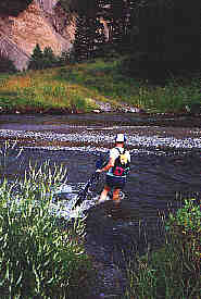
The Williams
Lake Field Naturalists Club (1978) felt that the beaver dams and the shallow
water depths in the river resulting from the lake controls have prevented
the pink salmon from spawning the full length of the creek. Eighty five
years ago the pink salmon navigated the full length of the river, passing
upstream through Williams Lake to the San Jose River. In recent years
counts of about 600 pink salmon have been found in the shallow water of
the Williams Lake River about 1 km. upstream from the Fraser River.
Salmon fry hatch
in February and emerge in April or May, leaving immediately for the Pacific
Ocean. They return to the river after their two year life cycle to reproduce
and die. The survival of their eggs depends on the amount of oxygen available
to them. The Williams Lake Field Naturalists Club (1978) had concerns
whether the effluent transported from the City had caused a depletion
in the amount of dissolved oxygen in the water resulting in the death
of the salmon eggs and fry. This effluent is no longer dumped into the
Williams Lake River but transported by the sewage trunk line to the Fraser
River.
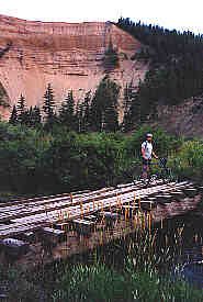
Caution
should be exercised on the bridges. There are twenty six bridges locations
in the valley plan. Twenty of those bridges were built about 1980 and
several have fallen into disrepair or have been washed out. Under the
new recreation plan, many bridges are planned for renewal or new construction
in 1996 under sponsorship of Forest Renewal BC and BC Forest Service/City
of Williams Lake.
All visitors
are urged to be cautious and travel in groups. The area has natural hazards
and children/pets are at risk from natural elements; the occassional bear,
cattleguard, rockfall and meandering trail network means that common sense
is a requirement. Please avoid the private land and railway tracks. Enjoy
your visit to this very special place.
-
taken in part from the Williams Lake River Valley Trail Study
prepared by NordicGroup International

 Many other