The
130km (80miles) trip up The Sunshine
Coast starts from Langdale, the first ferry
terminus and goes to the Lund, the northern end of Highway 101. Along
the journey are two very different ferry crossings, beautiful inlets,
deep fjords, sandy beaches and stunning forests. Summers
are sunny and dry, winters mild and wet. This region receives about 2,400
hours of sunshine a year with just 94 cm (37 in.) of rain.
To
reach the Sunshine Coast, take the ferry from Horseshoe Bay across the
Howe Sound to Langdale.
Gibsons:
Overlooking the Shoal Harbour and the Howe Sound is Gibsons. With pleasant
walks, restaurants and shopping, Gibsons is a relaxing town to spend some
time.
Elphinstone
Pioneer Museum:
Focusing on the Sunshine Coast's natural and First Nations history, this
museum is located at 716 Winn Road.
Roberts
Creek:
7km (4miles) west of Gibsons, off of Highway 101 along the scenic Lower
Roberts Creek Road is Roberts Creek. There are plenty of bed-and-breakfasts
in this peaceful area.
Roberts
Creek Provincial Park:
This is a good place to look for mussels, oysters and sea stars at low
tide.
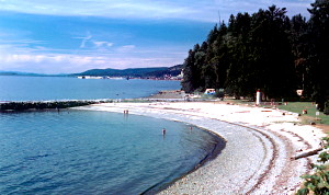
Sechelt:
This "place of shelter from the sea" is 21km (13miles) north
of Gibsons on Highway 101. Situated on a sandbar with the Straits of Georgia
to the south and the Sechelt Inlet to the north, this village is the base
for the Sechelt People. After nearly being wiped out by small pox in the
1860's the Sechelt Nation is thriving now. Visit Snickett Park and Pebble
Beach for good swimming, salmon fishing, cruising and scuba diving.
House
of Hewhiwus (House of Chiefs): A museum, the Raven's Cry Theatre,
the Sechelt Indian Government Administration Office and the South Campus
of Capilano Community College are located here.
Rockwood Lodge Gardens: This restored 1936 building is
surrounded by gardens.
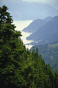
From
Sechelt as you head north along the coast line, you'll go by. As you travel
towards Pender Harbour the highway starts to wind and climb. As you enter
Pender Harbour, the ocean view and small islands offer a spectacular view.
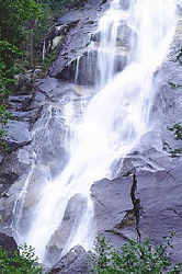
make up the communities in the harbour. From here you can take a side
trip to Egmont and Skookumchuck Narrows. As the tides move through the
narrows they form rapids that roar. The 45-minute hike is well worth your
time and effort.
Images
courtesy of Tourism Powell River
Continuing
north along the coast line you will pass by Porpoise Bay Provincial Park,
Sargeant Bay Provincial Park, Halfmoon Bay Lookout, and Halfmoon Bay.
Upon entering Pender Harbour you will find the communities of Madeira
Park, Irvines Landing and Garden Bay. Back
on Highway 101 you will continue onto Earl's Cove. From here are BC
Ferries to Saltery Bay and Powell River.
Powell
River:
31km (19miles) north of Saltery Bay is Powell River, the largest community
between West Vancouver
and Prince Rupert.
Scuba
diving is a well known sport in Powell River, with 20 major dive sites,
clear waters and abundant sea life. There are a number of historic commercial
buildings and many Victoria-style homes throughout the area.
Powell
River Historic Museum:
With the 3rd largest photo archives in BC, the museum is located on Highway
101 across from Willingdon Beach.
Powell
Forest Canoe Route:
Beginning at Lois Lake, over 80 km (50 miles) of portages and streams
connect 12 lakes.
From
Powell River you can take BC Ferries to Comox on Vancouver Island and
Texada Island or continue north on Highway 101 to Lund
Lund:
The northern most tip of Highway 101, Lund is 23km (14miles) north of
Powell River and provides access to nearby marine parks, fishing holes
and Savory Island
Now
accepting listings! To find out more, contact
Alan Forseth alan@ibcnetwork.com
Phone (250) 377-4144 or Toll Free: 1-877-325-7770
The following BC Adventure members would like to serve you:

 Elphinstone
Pioneer Museum:
Elphinstone
Pioneer Museum: